Orrun · The Eternal Path
The Raven Scholar map of Orrun
Explore Orrun and the Imperial Island from Antonia Hodgson’s The Raven Scholar. Move from the empire’s coasts to the island at its heart, where Guardian palaces, the Grand Canal and bridges form a detailed 3D diorama.
In this atlas
What you can explore
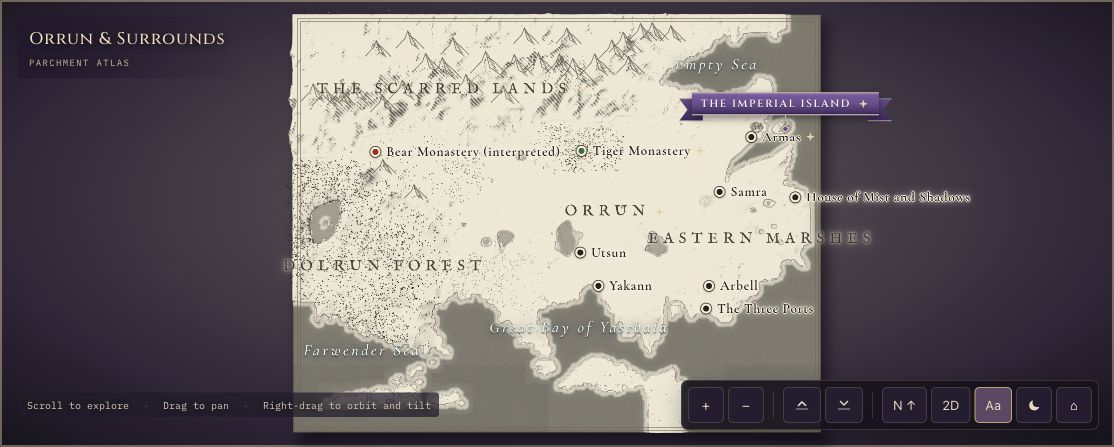
The Orrun & Surrounds map gives the wider setting: the empire, nearby waters and places such as Armas and the Scarred Lands. Open the Imperial Island for a closer view of its palaces, library, temple and gardens. Armas is a location on the overview, rather than a separate detailed city scene.
- Open Orrun & Surrounds
The wider setting
Orrun & Surrounds map
Start with the wider realm, then find Armas, surrounding waters and the island’s place in the empire.
- Open The Imperial Island
A closer view
The Imperial Island map
Explore the eight Guardian palaces, Grand Canal, bridges, Imperial Library and temple from above.
A route through the map
The two maps use different orientations. The Imperial Island’s printed map places east at the top; the 3D compass follows that orientation. Use the compass and labels when moving between the empire and the island.
Try these starting points:
Questions about this map
What does The Raven Scholar map cover?
RuneCharted has two connected maps for Antonia Hodgson’s The Raven Scholar: Orrun & Surrounds, and the Imperial Island. Use Orrun for the wider setting and the island scene for the Guardian palaces, Grand Canal and Imperial Library.
Is there a detailed Imperial Island map?
Yes. The Imperial Island is a separate interactive scene with eight Guardian palaces, bridges, gardens and the canal. Its buildings are original fan interpretations. The compass follows the east-at-the-top orientation of the island reference map.
Can I use this map while listening to the audiobook?
Yes. Open the guide alongside the audiobook, then use the map’s Find a place field when a location comes up. Place and character names may appear before you encounter them in the story; there is no filter for your current chapter.
Geography and artistic interpretation
The atlas uses the printed geography and the project’s book research as references. Building shapes, colours and architectural details are original interpretations. An imagined palace model should not be read as an official floor plan.
Before you explore: spoilers
These maps focus on the setting. Place descriptions and character cameos may still reveal names encountered during the novel; the atlas is a reading companion rather than a chapter-by-chapter spoiler filter.