The Continent · The Empyrean
Fourth Wing map of Navarre and Basgiath
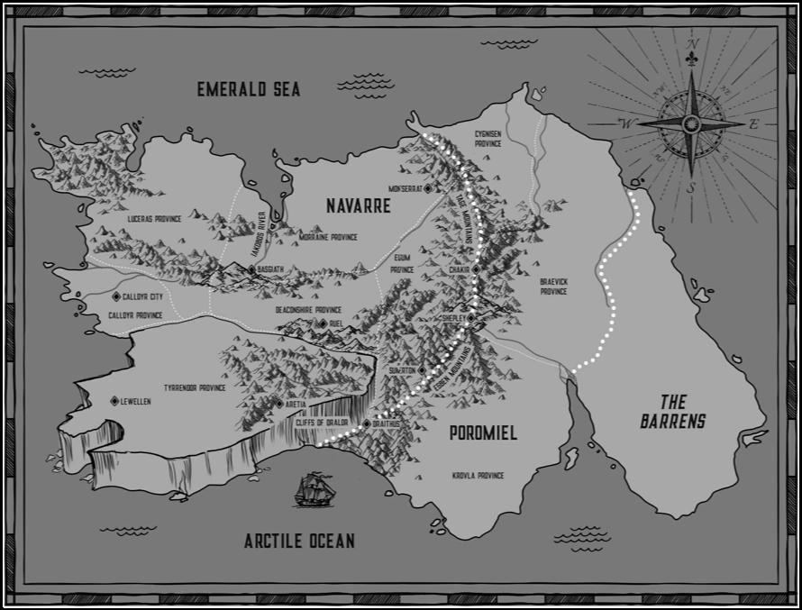
Start with the published map from Rebecca Yarros’s Fourth Wing, then zoom into an interactive 3D landscape. Explore Navarre, Poromiel and the Barrens, or open the school map of Basgiath War College.
In this atlas
What you can explore
The continent includes all ten settlement markers printed in the standard first-book map: Calldyr City, Basgiath, Montserrat, Chakir, Shepley, Sumerton, Ruel, Lewellen, Aretia and Draithus. Athebyne and Resson are additional text-based locations, clearly marked approximate. Basgiath has a separate scene based on the published campus illustration.
- Open The Continent
The wider setting
The Continent map
Published coastlines and town markers, the Tage–Esben mountain chain, Tyrrendor’s plateau, plains and rivers.
- Open Basgiath War College
A closer view
Basgiath War College map
The published campus map, four quadrants, Dragon Rotunda, river gorge, parapet, Gauntlet and flight field.
A route through the map
Zoom all the way out to see the actual published plate. Move closer to reveal the terrain and buildings. The continent is north-up. The pictorial school plate has a different orientation; the campus compass follows the north/south relationship described in chapter one.
Try these starting points:
Questions about this map
Where is Basgiath on the Fourth Wing map?
Basgiath lies in central Navarre, beside the headwaters of the Iakobos River and an east–west mountain range. Select its continent marker or open the Basgiath campus tab for a closer view.
Can I zoom into the published Basgiath map?
Yes. The school scene opens with the actual published campus illustration. Zoom closer to explore the four quadrants, Dragon Rotunda, parapet, Gauntlet and flight field in 3D.
Are every city’s streets exact?
The ten printed settlement positions follow the map. Individual town streets are interpreted because no published street plan was found for them. The campus uses its published pictorial plan; building heights and facade details remain interpretations.
Does this include Iron Flame or Onyx Storm?
This pack focuses on Fourth Wing’s first-book setting. It does not add later-book cities or the Onyx Storm isles to the published map.
Geography and artistic interpretation
The overview images are the published plates, not AI recreations. Continental markers and the major campus footprints are registered to those images. The book does not publish detailed street plans for each town: streets, house counts, facades, colours and terrain heights are original interpretations. Plains, mountain belts and the cliffed plateau follow the geographical evidence. Snow is reserved for high peaks. Athebyne and Resson are not marked on the original plate and have approximate positions.
Read this map’s source and interpretation notes. The research notes may discuss later-book geography.
Before you explore: spoilers
First-book setting and place names, without later battle outcomes. Aretia is shown as ruined at the beginning of Fourth Wing. Later-book cities and the Onyx Storm isles are outside this pack; there is no chapter-by-chapter filter.