Hogwarts grounds · Harry Potter
Harry Potter map of Hogwarts and Hogsmeade
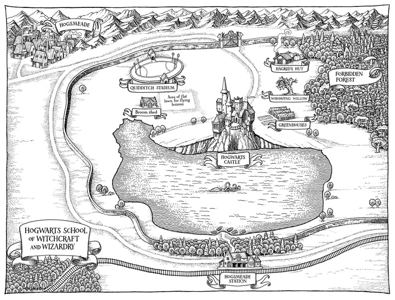
Start with Tomislav Tomić’s Hogwarts grounds map from Bloomsbury’s children’s editions. Zoom into the lake, woodland and castle, then explore the shops and crooked rooftops of Hogsmeade.
In this atlas
What you can explore
This pack covers the school grounds and neighbouring Hogsmeade shown on the published map. It includes all of that illustration’s named outdoor locations, plus ten researched village shops and landmarks. It does not cover London, the full United Kingdom, film sets or Hogwarts Legacy.
- Open Hogwarts & Hogsmeade
The wider setting
Hogwarts & Hogsmeade map
One continuous map: the printed overview, castle promontory, six-hoop Quidditch pitch, flying lawn, cabin, willow, greenhouses, forest, lake, gates, station, railway and village.
A route through the map
Open the full published map first, then scroll or pinch closer. Select a place to fly there, tilt to see the round turrets and roof shapes, and use night mode for warm windows and village lanterns. The home control returns to the complete book map.
Try these starting points:
Questions about this map
Which published Harry Potter map is this?
The Hogwarts grounds illustration drawn by Tomislav Tomić for Bloomsbury’s 2014 children’s editions. The original 1997 first printing did not contain this map.
Is this an exact Hogsmeade street map?
No. The village’s position follows the book map, while shop locations and individual streets are clearly marked interpretations informed by the books’ descriptions.
Does it include Diagon Alley or Hogwarts Legacy?
This map covers Hogwarts and Hogsmeade. Diagon Alley is in London and outside this published map’s extent; game-only locations and film-set layouts are not imported.
Can I explore the castle inside?
The castle is an exterior diorama. You can zoom, rotate, tilt and use night mode, but there are no walkable rooms.
Geography and artistic interpretation
Five distinct maps were visually reviewed: Tomić’s children’s edition plate, Pinfold’s anniversary grounds map, Rowling’s original sketch and Peter Goes’s two Wizarding Almanac maps. The displayed Tomić plate anchors the outdoor positions. It is a pictorial illustration rather than a measured survey. Hogsmeade shop lots, street details, castle wings, heights, materials and early-autumn colours are original interpretations. There is no published exact street plan for these shop positions. The castle has exterior architecture only.
- Hogwarts map for the 2014 children’s editions
- Hogwarts Castle and Grounds, 20th anniversary editions
- Sketch of Hogwarts by J. K. Rowling
- Hogwarts grounds, The Harry Potter Wizarding Almanac
- An Unguided Tour of Hogwarts, Wizarding Almanac
Read this map’s source and interpretation notes. The research notes may discuss later-book geography.
Before you explore: spoilers
The card uses the first UK book title, also published as Harry Potter and the Sorcerer’s Stone in the US. The map uses a peaceful series-era setting: some place and shop names appear in later books. Secret passage routes, later plot outcomes and battle damage are not shown. There is no chapter-specific spoiler filter.