Westeros · A Song of Ice and Fire
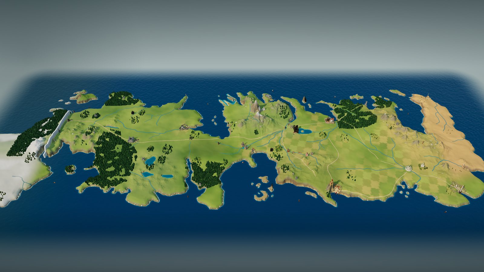
A Game of Thrones map of Westeros
Start with the two maps printed in George R. R. Martin’s A Game of Thrones, The North and The South, joined into one Westeros. Then zoom from the Wall and Winterfell down the kingsroad to King’s Landing, the Reach and Dorne.
In this atlas
What you can explore
The map covers the Seven Kingdoms as the first book’s maps print them: 70 named places from beyond the Wall to Sunspear, among them Castle Black, Winterfell, Moat Cailin, the Twins, Riverrun, Harrenhal, the Eyrie, King’s Landing, Dragonstone, Storm’s End, Casterly Rock, Highgarden, Oldtown and Pyke. Zoom in on the capital for King’s Landing: its walls and seven gates, the Red Keep, the Great Sept of Baelor, the Dragonpit, Flea Bottom, the harbour and the tourney grounds. Zoom in on Winterfell for the Stark castle: its two walls and moat, the Great Keep, the godswood and its heart tree, and the winter town. Essos is outside this pack.
- Open Westeros
The wider setting
Westeros map
One continuous map: both published sheets, the Wall from coast to coast, the kingsroad, the Trident and its forks, the Mountains of the Moon, the Reach, the Red Mountains and the Iron Islands.
A route through the map
Zoom all the way out to see the two published sheets, joined where they overlap at the Neck. Move closer to reveal terrain, castles and towns, or select a place to fly there. Night mode lights the Wall, the Hightower’s beacon and the windows of the great cities. Select King’s Landing or Winterfell to open the city or the castle itself and walk its streets by lamplight. The home control returns to the whole of Westeros.
Try these starting points:
Questions about this map
Which A Game of Thrones map is this?
The two maps drawn by James Sinclair for the first Bantam edition of A Game of Thrones (1996): “The North”, from beyond the Wall to the Twins, and “The South”, from the Neck to Dorne. The sheets overlap across the Neck and the northern riverlands, where the atlas joins them into one Westeros.
Where is the Wall on the map of Westeros?
Across the far north, from coast to coast. The Shadow Tower stands in the west, Castle Black where the kingsroad ends, and Eastwatch-by-the-Sea on the Bay of Seals. The Haunted Forest lies beyond it.
Does this map include Essos or the Free Cities?
No. This pack covers Westeros, the land shown on the maps of the North and the South. Pentos, Vaes Dothrak and the other places in Daenerys’s chapters lie across the narrow sea in Essos, outside this pack.
Is this the HBO Game of Thrones map?
No. Positions follow the books’ published maps. Castles, cities, heights and colours are original 3D interpretations informed by the novels, not the television series’ sets or opening titles.
Can I see Westeros at night?
Yes. Switch to night to see the Wall glow pale blue, the beacon burning atop the Hightower in Oldtown and lamplight in the windows of King’s Landing, Winterfell and the other great castles.
Can I explore King’s Landing up close?
Yes. Zoom in on the city on the map of Westeros to walk the capital: its walls and seven gates, the Red Keep on Aegon’s High Hill, the Great Sept of Baelor on Visenya’s Hill, the Dragonpit on the Hill of Rhaenys, Flea Bottom, the harbour and the tourney grounds outside the King’s Gate. The plan follows Jonathan Roberts’s official King’s Landing map from The Lands of Ice and Fire.
Geography and artistic interpretation
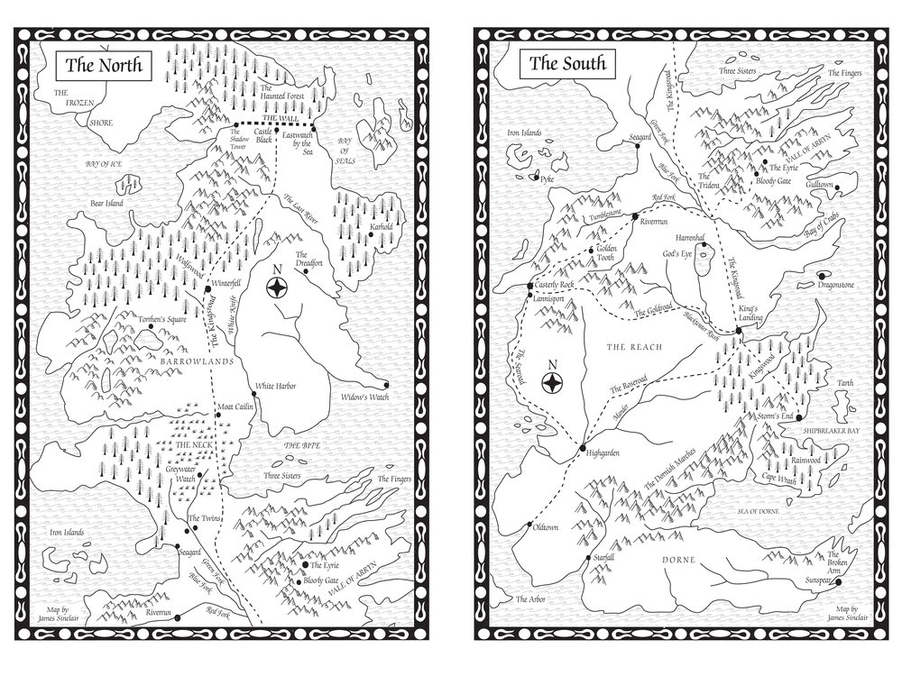
The overview shows the published maps, not an AI recreation. Coasts, rivers, roads, forests, mountain ranges and all 70 places were traced from Sinclair’s two sheets and registered to one frame. Two more maps were layered on top: Cuivienen’s map of the whole continent, used to check positions across the join, and A Wiki of Ice and Fire’s plan of King’s Landing, used to place the Red Keep, the Great Sept of Baelor and the Dragonpit on their hills. Inside Winterfell, the walls, gates and buildings follow Riusma’s plan of the castle on A Wiki of Ice and Fire, with silhouettes after Ted Nasmith’s painting in The World of Ice & Fire. Castle architecture, house counts, colours and terrain heights are original interpretations informed by the novels. The Hightower is described in the text but not drawn on the book map, so it stands beside Oldtown as an interpretation. The King’s Landing layout follows Jonathan Roberts’s official city map from The Lands of Ice and Fire for its walls, gates, hills, squares and great buildings, checked against the wiki plan; its houses, lesser streets and building forms are interpretations.
- A Game of Thrones, Bantam (Penguin Random House)
- Westeros, A Wiki of Ice and Fire
- Wall, A Wiki of Ice and Fire
- King’s Landing, A Wiki of Ice and Fire
- Map of the Westeros continent by Cuivienen, Ice and Fire wiki
- King’s Landing, The Lands of Ice and Fire, by Jonathan Roberts

Read this map’s source and interpretation notes. The research notes may discuss later-book geography.
Before you explore: spoilers
Westeros as it stands in 298 AC, when A Game of Thrones begins, with the realm at peace under King Robert. Later sieges, burnings and battle damage are not shown. Essos, where Daenerys’s chapters take place, is outside this pack. Some streets and gates of King’s Landing are first named in later books; they appear only as places. There is no chapter-by-chapter filter.