Six Duchies · Assassin’s Apprentice setting
Six Duchies map: Assassin’s Apprentice in 3D
Explore the Six Duchies from Robin Hobb’s Assassin’s Apprentice, the first book of the Farseer Trilogy: start with the map printed in the book, then zoom into an interactive 3D coast of slate towers and fishing harbours, with Buckkeep above the mouth of the Buck, Forge, Moonseye and Jhaampe in the Mountain Kingdom.
In this atlas
What you can explore
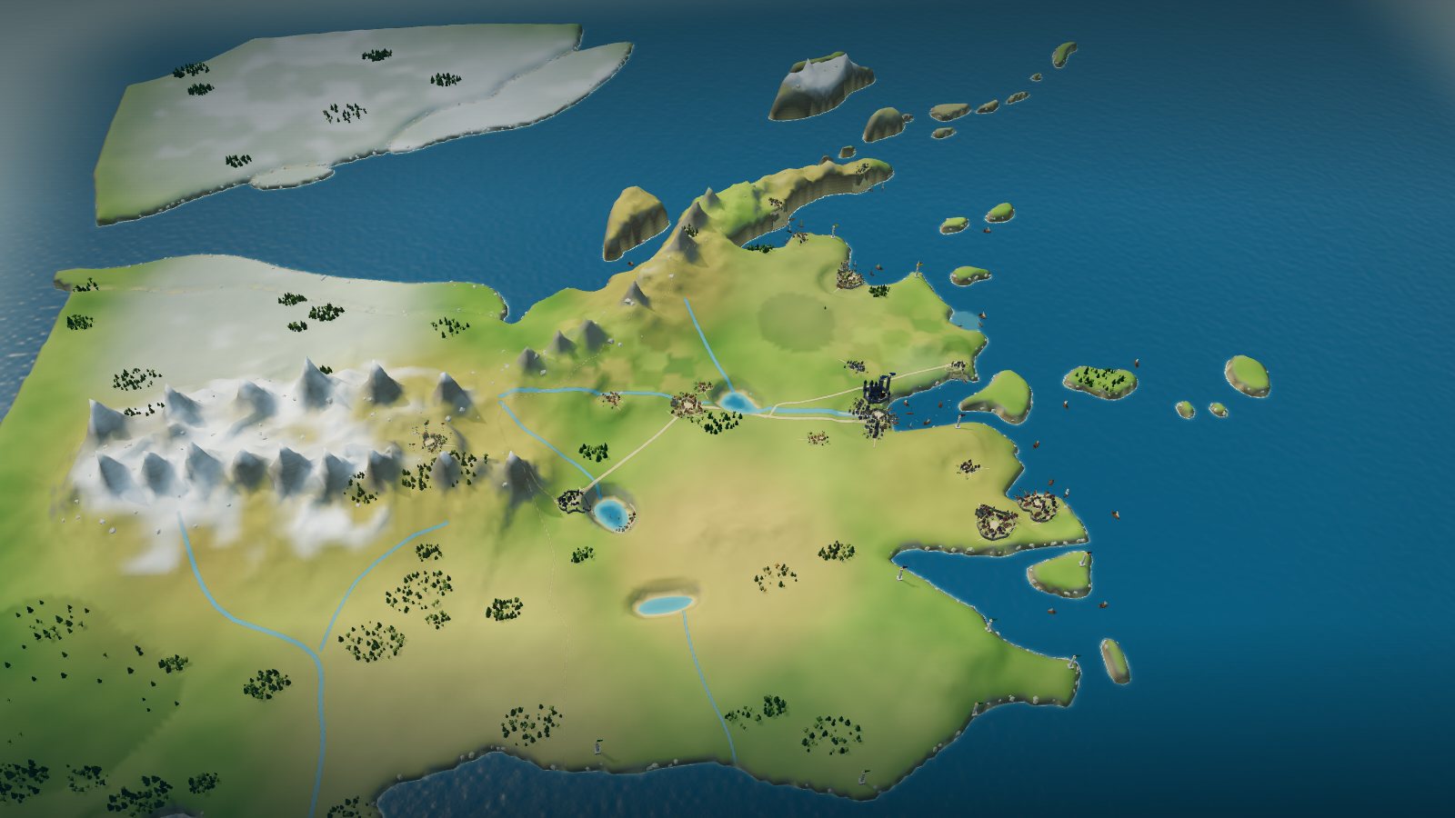
The map opens like the one printed in the book, with the six duchies of Buck, Bearns, Rippon, Shoaks, Tilth and Farrow along a cold northern coast, the icy shelves of the White Sea above them, the Mountain Kingdom and Jhaampe in the west and the Chalced border in the south. Zoom closer and the printed coasts, rivers, lakes and ranges rise into terrain, with Buckkeep Castle and the town below it, Forge, Moonseye, the walled seats of Ripplekeep, Neatbay, Bayguard and Tradeford, and the ten watchtowers along the shore. The same world continues in the Realm of the Elderlings, and Bingtown and the Rain Wilds are printed on the map at its south-western edge, but this atlas shows no events from the later books. Buckkeep Castle, Buckkeep Town, Moonseye, Forge and Jhaampe are laid out in detail as you zoom in.
- Open The Six Duchies
The wider setting
The Six Duchies map
The printed map with its coasts, islands, bays, Turlake and the Bear, Vin and Buck rivers, the Bearns and Tilth ranges, the Glacier Plains and the Icy Shores traced, nineteen settlements built, Buckkeep Castle on its bluff above the town, ten coast towers with beacons, and the Mountain Kingdom border drawn dashed.
A route through the map
Zoom all the way out to see the printed map unchanged. Move closer to reveal the terrain, coasts and towns. The map is north-up, as the book prints it. Select a place to fly there; night mode lights Buckkeep’s hall and the lamp in Verity’s tower, a beacon on each coast tower, the lantern-lit tents of Jhaampe and the gate fires of Moonseye under a moonlit sea. Select Buckkeep to climb the bluff into the castle: by night the keep’s windows and the Great Hall glow gold, the lamp burns at the top of Verity’s tower, lanterns light the gate, kitchens and stables, and blue banners hang over the courtyard above the moonlit bay. Select the town below it for the harbour at night: lanterns along the piers and the quay, the lit doors of the inns, the market square under strings of lamps and bunting, and the boatyard shed glowing beside the Buck mouth. Select Moonseye to cross to the lake: torches burn at both gates, the garrison hall’s windows glow, fires and lanterns light the caravan yard and the camp on the Chelika trail, and the lantern-lit jetty glitters on Blue Lake. Select Forge to follow the coast east: the smithy doors and chimneys glow orange, lamps burn at the three mine mouths and the ore house under the ridge, the jetty and net loft are lantern-lit, and the moon glints on the sea beyond the headland. Select Jhaampe to climb into the Mountain Kingdom: the Palace of the Sacrifice glows from within like a lantern with a bright bud top, the Great Library’s windows and painted porch are lit, lamps shine in the public gardens, cook fires and tents glow at the camping grounds, steam rises from the bath houses and the moon glints on the tarn.
Try these starting points:
- Buckkeep (castle and town)
- Buckkeep Castle
- Seawatch Tower
- Buckkeep docks
- Buckkeep markets
- Moonseye caravan market
- Forge
- Forge ore workings
- Palace of the Sacrifice
- Moonseye
- Jhaampe
- Ice Town
- Bingtown
- The Rain Wilds
- The Mountain Kingdom
- Ripplekeep
- Bayguard
- Neatbay
- Tradeford
- Turlake
- Buck River
- Vin River
- Glacier Plains
- Chalced States
- The Out Islands
- The White Sea
Questions about this map
Where is Buckkeep in the Six Duchies?
Buckkeep stands on the south bank at the mouth of the Buck River, on the coast of the Buck duchy, with the Bay of Buck just east of it. On the printed map it is a labelled dot; the atlas builds the town on the harbour and the castle on a bluff above it, a design drawn from the book’s descriptions, not a printed plan.
Where are Verity’s tower, the stables and Chade’s den in Buckkeep Castle?
Zoom in on Buckkeep on the map to find the castle. Seawatch Tower (Verity’s tower) stands on the seaward south-east edge of the bluff, the stables with Burrich’s rooms and the kitchens lie on the gate side toward the town, the Great Hall is by the keep’s main door, and the Queen’s Garden and Chade’s Den sit on the landward north side. No plan of the castle is printed, so this layout is an editorial reading of the wiki and the book’s descriptions.
Where are the docks, markets and boatyards of Buckkeep Town?
Zoom in on Buckkeep on the map to find the town. The docks and their piers lie on the stone quay on the south shore of the bay, the boatyards on the beach at the bay head beside the quay’s west end, the markets on a paved square between the quays and the bridge road, the taverns by the quay, and the Buck River opens into the bay head just north of the town under the castle’s bluff. The book names only the docks, boatyards and markets, so the town plan is an editorial reading, not a printed one.
Which duchies make up the Six Duchies?
Buck, Bearns, Rippon, Shoaks, Tilth and Farrow. The printed map labels each, with Bearns in the north, Buck on the central coast, Rippon and Shoaks down the south, and Tilth and Farrow inland to the west.
Where is the Mountain Kingdom and its city Jhaampe?
The Mountain Kingdom lies in the west beyond the ranges, its border drawn dashed on the printed map. Jhaampe is the labelled dot at its heart; the printed J looks like a T, so some readers search it as Thaampe. Zoom in on its dot to see the valley: the atlas draws a loose camp-style capital of low huts and tents, the Palace of the Sacrifice shaped like a closed tulip bud, the Great Library, the public gardens and the camping grounds, which is an interpretation.
Where are Forge and Moonseye on the map of Assassin’s Apprentice?
Forge is on the Buck coast to the north-east of Buckkeep, across from the mouth of the Buck, below the hills. The printed map does not mark Moonseye; it is placed by the book and the reference maps on the shore of Blue Lake in the south-west, so its position is interpretive.
What is there to see in Moonseye, and where do the Chelika trail and the lake landing run?
Zoom in on Moonseye’s dot on the map. The walled town sits on the Mountain Kingdom shore of Blue Lake with a gate in the west and one in the east; just inside the west gate lie the garrison hall, the caravan provisioning market and the stables, the Chelika trail climbs west from that gate into the hills, and the lake road runs east from the other gate to the Blue Lake landing, a jetty with barges on the shore. The book and the wiki give only that Moonseye is small, fortified and a stopping place for caravans, so the plan, walls and buildings are an editorial reading, not a printed one.
What is there to see in Forge, and where are the ore workings and the road to Buckkeep?
Zoom in on Forge’s dot on the map. The wall-less ore town sits on a headland of the Buck coast with the sea to the east and south: the market square and smithies at its heart, the timber jetty and boats on the east shore, the ore workings with their lamplit mine mouths under the ridge to the north-west, and the road to Buckkeep leaving by the west side. The book and the wiki give only that Forge is a small coastal town named for its metal ore, so the plan and buildings are an editorial reading, not a printed one.
What is there to see in Jhaampe, and where are the palace, the library and the camping grounds?
Zoom in on Jhaampe’s dot on the map. The unwalled capital of the Mountain Kingdom lies in a high valley between snow-capped ranges, with a tarn and stream beside it: the Palace of the Sacrifice stands at the centre like a closed tulip bud in yellow, orange and purple, the Great Library is a low timber-and-plaster hall just east of it, the public gardens lie to the west, and the camping grounds with their ring of tents sit on open ground at the western edge. The book and the wiki give only that Jhaampe is a city of few permanent buildings among tents and huts, so the plan and buildings are an editorial reading, not a printed one.
Where are Bingtown and the Rain Wilds in relation to the Six Duchies?
Both are printed at the south-western edge of the map, past the Chalced States. The atlas shows them only as names, for readers who come from the Realm of the Elderlings, and shows nothing of the later books there.
Is the Six Duchies map the same in the Farseer Trilogy and the Realm of the Elderlings?
The Six Duchies are the same country across the series, and the reference maps registered here draw the wider Realm of the Elderlings round it. This atlas traces the map printed in Assassin’s Apprentice and uses the others only for names and shapes, so it shows the Six Duchies as book one leaves them.
Geography and artistic interpretation
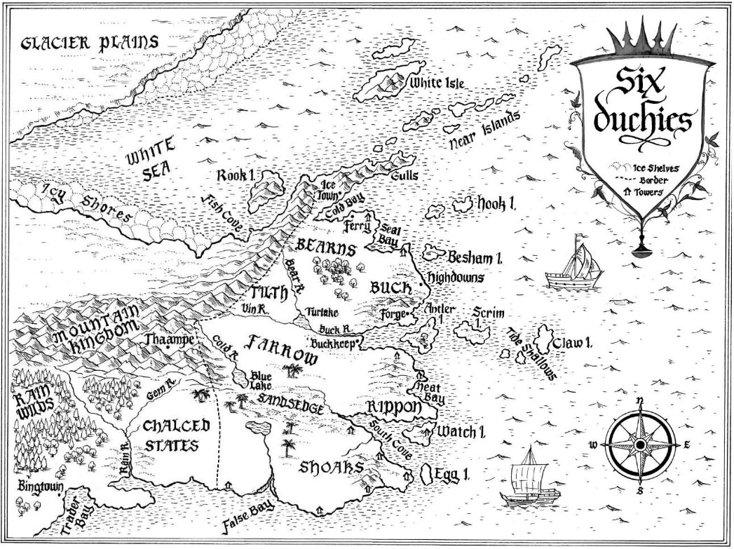
Four maps were used: the Six Duchies plate printed in the book, as filed on the Realm of the Elderlings wiki (the template, shown at overview; its mapmaker and edition are not credited there), and three reference maps registered onto it, Narwen’s Six Duchies map, the @cartographer_jsm Realm of the Elderlings map and an uncredited illustrated Realm map, which supply the names the printed map leaves out. Roads, trails, the harbours and a few villages are placed from the reference maps or the text and marked interpretive; building forms, terrain heights, colours and night lighting are original interpretations, not official art. The castle’s layout is an editorial plan drawn from the wiki and the book’s descriptions; no plan of it is printed. The town is likewise an editorial plan: the book names only its docks, boatyards and markets, so the streets, houses and inns are drawn, not read. Moonseye is another: the sources give a small fortified caravan town on Blue Lake, so its walls, gates, yard, stables and landing are drawn, not read. Forge is the same: the sources give a small coastal ore town in Buck, so its smithies, market square, ore workings, jetty and road are drawn, not read. Jhaampe is the last: the sources give a loose capital of tents and few permanent buildings, a palace like a closed tulip and a great library, so its huts, lanes, gardens and camp are drawn, not read.
- Realm of the Elderlings Wiki: The Six Duchies (fan wiki, read through its API)
- Realm of the Elderlings Wiki: Buckkeep
Read this map’s source and interpretation notes. The research notes may discuss later-book geography.
Before you explore: spoilers
Places are shown as the first book leaves them, with a calm coast. Later-book places and the Liveship and Rain Wilds names printed beyond the map are kept out, and Bingtown and the Rain Wilds appear only as names at the map’s south-western edge. Place cards paraphrase the book with chapter locators and quote nothing.