Narnia · The Lion, the Witch and the Wardrobe setting
Narnia map: The Lion, the Witch and the Wardrobe in 3D
Explore Narnia from C. S. Lewis’s The Lion, the Witch and the Wardrobe, the first of the Chronicles of Narnia: start with Pauline Baynes’s map of Narnia, then zoom into an interactive 3D land of snow and thaw, with the lamp-post, Mr Tumnus’s cave, the Beavers’ dam, the White Witch’s house, the Stone Table and Cair Paravel.
In this atlas
What you can explore
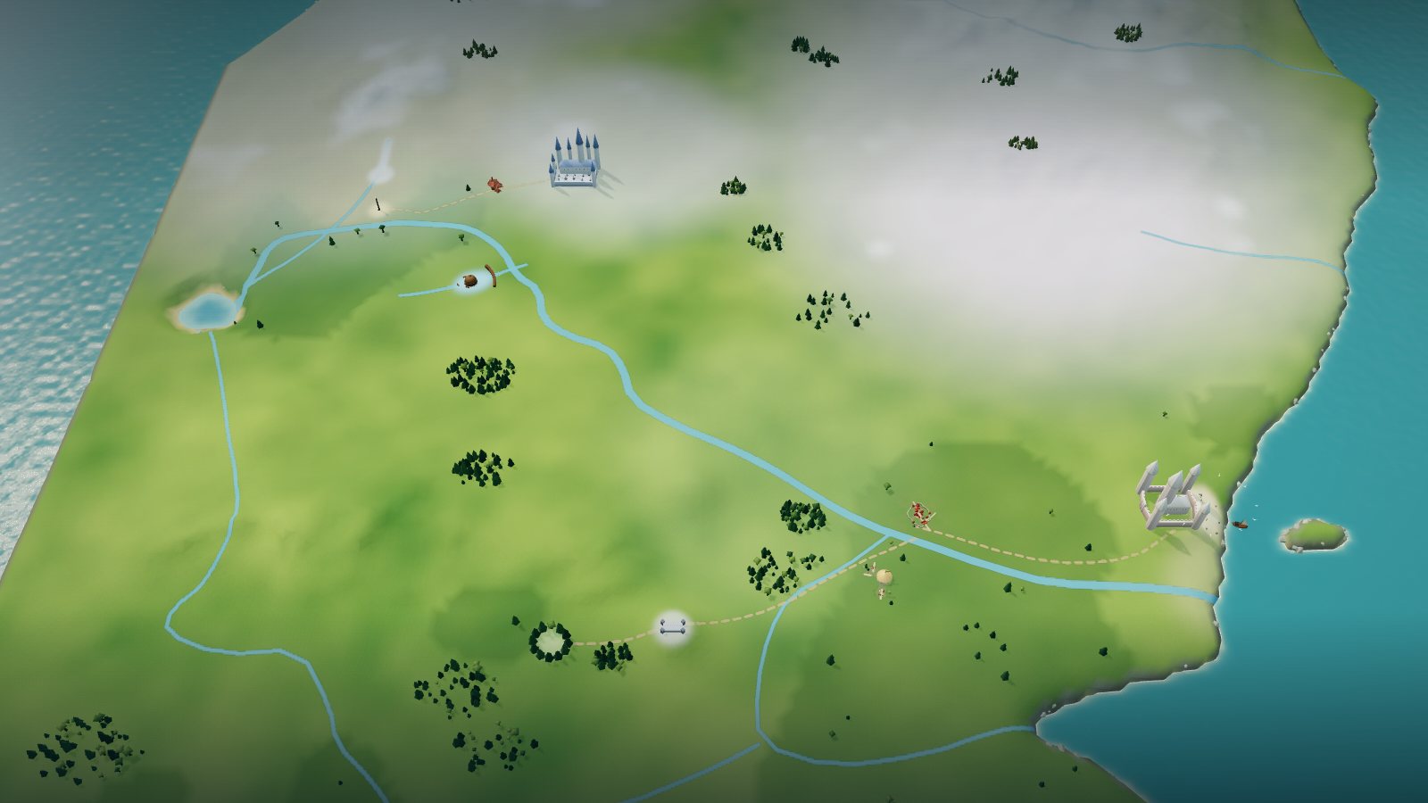
The map opens as Pauline Baynes drew it for her 1972 poster map of Narnia and the surrounding countries: the Great River running from the western falls and Cauldron Pool to the sea beside Cair Paravel, the Lantern Waste woods in the north-west, the Wild Lands of the North above them and the hills and fords in between. Zoom closer and the printed coasts, rivers and ranges rise into terrain, wintry white in the north and west and green with spring in the south and east, with a lit lamp-post, Mr Tumnus’s cave in the rock, the Beavers’ dam and lodge, the needle-roofed White Witch’s house, the Stone Table, the pale-rose towers of Cair Paravel and Aslan’s camp by the Fords of Beruna. Lands beyond Narnia, such as Archenland, Calormen and the islands, are named on the printed map and are kept out of sight here, for readers meeting the Chronicles in order.
- Open Narnia
The wider setting
Narnia map
The printed map with its coast, rivers, Cauldron Pool, ranges and woods traced, the lamp-post, Mr Tumnus’s cave, the Beavers’ dam, the White Witch’s house with its statues, the Stone Table, Cair Paravel on the shore, Beruna and Aslan’s camp at the fords built, a lit night, and the tracks that join them drawn faintly.
A route through the map
Zoom all the way out to see the printed map unchanged. Move closer to reveal the terrain, coasts and buildings. The map is north-up, as Baynes draws it. Select a place to fly there; night mode lights the lamp-post, the windows of Mr Tumnus’s cave, the Beavers’ dam, the cold glow of the White Witch’s house, the Stone Table and Cair Paravel under a bright starry sky.
Try these starting points:
- The Lamp-post
- Mr Tumnus’s cave
- The Beavers’ dam
- The White Witch’s house
- The Stone Table
- Cair Paravel
- The great hall with the four thrones
- The east door to the sea
- The shore and river mouth below the castle
- The courtyard of statues
- The Witch’s hall
- The turrets of the White Witch’s house
- The firelit room with the tea table
- Mr Tumnus’s cave door
- The lodge on the dam
- The dam across the river
- The Stone Table itself
- The bare hilltop around the Stone Table
- Lantern Waste
- The Great River
- Beruna
- Fords of Beruna
- Wild Lands of the North
Questions about this map
Where is the lamp-post in Narnia?
The lamp-post stands in the Lantern Waste, the woods in the north-west of Narnia. On the printed map it is a small medallion of a post with no label, near the caption “where Narnia began”, so the atlas reads it by its place and shape. In the book it is the light Lucy meets in the snowy wood after she steps out of the wardrobe (chapter 1).
Where is Mr Tumnus’s cave on the map of Narnia?
Just east of the Lantern Waste woods, a short walk from the lamp-post. The map prints it as a round cave-door medallion labelled Tumnus’s house. The atlas builds it as a rock with a round door and a lit window, drawn from the book’s description of the faun’s home (chapter 2); the interior is not shown.
Where are the Beavers’ dam and the Fords of Beruna?
The Beavers’ dam is drawn on the map where the stream below the Lantern Waste meets the Great River, south of Mr Tumnus’s cave. The Fords of Beruna are far downstream, near Beruna and Cair Paravel. The map marks only the name Beruna, so the fords and Aslan’s camp beside them are placed from the book and are interpretive.
Where is Cair Paravel on the map of Narnia?
On the eastern coast, where the Great River reaches the sea. The printed map draws it as a large pink-turreted castle with a dot on the shore. The atlas draws a pale-rose castle with an ivory hall, a keep and four turrets on the sands, with gulls and boats off the shore.
Can I go inside Cair Paravel in the atlas?
Select Cair Paravel on the map and zoom in to see the great hall of the four thrones, the east door that opens toward the sea and the sands where the Great River reaches the water. The book gives the hall an ivory roof and an open door to the sea (chapter 17), but no plan of the castle exists, so the layout of the hall, keep, towers and steps is RuneCharted’s interpretation; the rooms inside are not shown.
Can I go inside the White Witch’s house in the atlas?
Select the White Witch’s house on the map and zoom in to see the cluster of needle-spired turrets, the long low hall and the courtyard of stone creatures inside the open gate, standing alone in the snow. The book describes a low castle that seems made of nothing but towers, each ending in a sharp spire, and a yard of statues in the moonlight (chapter 9), but gives no plan, so the layout, the number and heights of the towers and the placing of the statues are RuneCharted’s interpretation; the rooms inside are not shown.
Can I go inside Mr Tumnus’s cave in the atlas?
Select Mr Tumnus’s cave on the map and zoom in to see the big reddish rock in a small snowy valley of the Lantern Waste, the little round-topped door in its foot with warm lanterns at the step, and a chimney and lit window that show where the firelit room lies. The book describes a snug, dry room with a bright fire, a tea table and a portrait of the faun’s father (chapter 2), but gives no plan, so the rock, the door’s spot and the position of the room are RuneCharted’s interpretation; the room inside is not drawn.
Can I go inside the Beavers’ dam in the atlas?
Select the Beavers’ dam on the map and zoom in to see the rounded wall of logs and mud across the frozen river, the pond held up behind it with snow-dusted ice and a few floes in the open channel, and the small beehive-shaped lodge on the dam with its round door, chimney and lit windows. The book describes the lodge as something like a large beehive, warm and homely inside, with a meal of fish, potatoes, bread and marmalade, and tea (chapter 7), but gives no plan, so the line of the dam across the valley and the lodge’s spot on it are RuneCharted’s interpretation; the rooms inside are not drawn.
Can I go up to the Stone Table in the atlas?
Select the Stone Table on the map and zoom in to see the bare hilltop in the middle of Narnia, a long grey slab on four standing stones at the centre of the level crown with its carved lines picked out in gold, a ring of trees on the slope below and the track winding up from the Fords of Beruna. The book describes a great grey slab raised on upright stones and cut with strange lines (chapter 13) on a hill with a bare top and woods at its edge (chapters 14 to 15), but gives no plan, so the shape of the hill, the size of the slab and the tracks are RuneCharted’s interpretation.
Where is the Stone Table in relation to the White Witch’s house?
They are at opposite ends of the land. The White Witch’s house is in the far north, at the edge of the Wild Lands of the North, beyond the Beavers’ dam. The Stone Table is far to the south, on the hill south of the Great River that the map labels Aslan’s How. Aslan’s How is the later name of that hill, so the atlas puts the first-book Stone Table there; that identification is an interpretation.
Is this map based on Pauline Baynes’s map of Narnia?
Yes. The overview is her 1972 poster map of Narnia and the surrounding countries, shown unchanged, and the coasts, rivers, ranges and names are traced from it. Her black-and-white version and a fan redraw are registered onto it only to read names and coast shapes. The buildings, terrain and lighting are RuneCharted’s own interpretation.
Geography and artistic interpretation
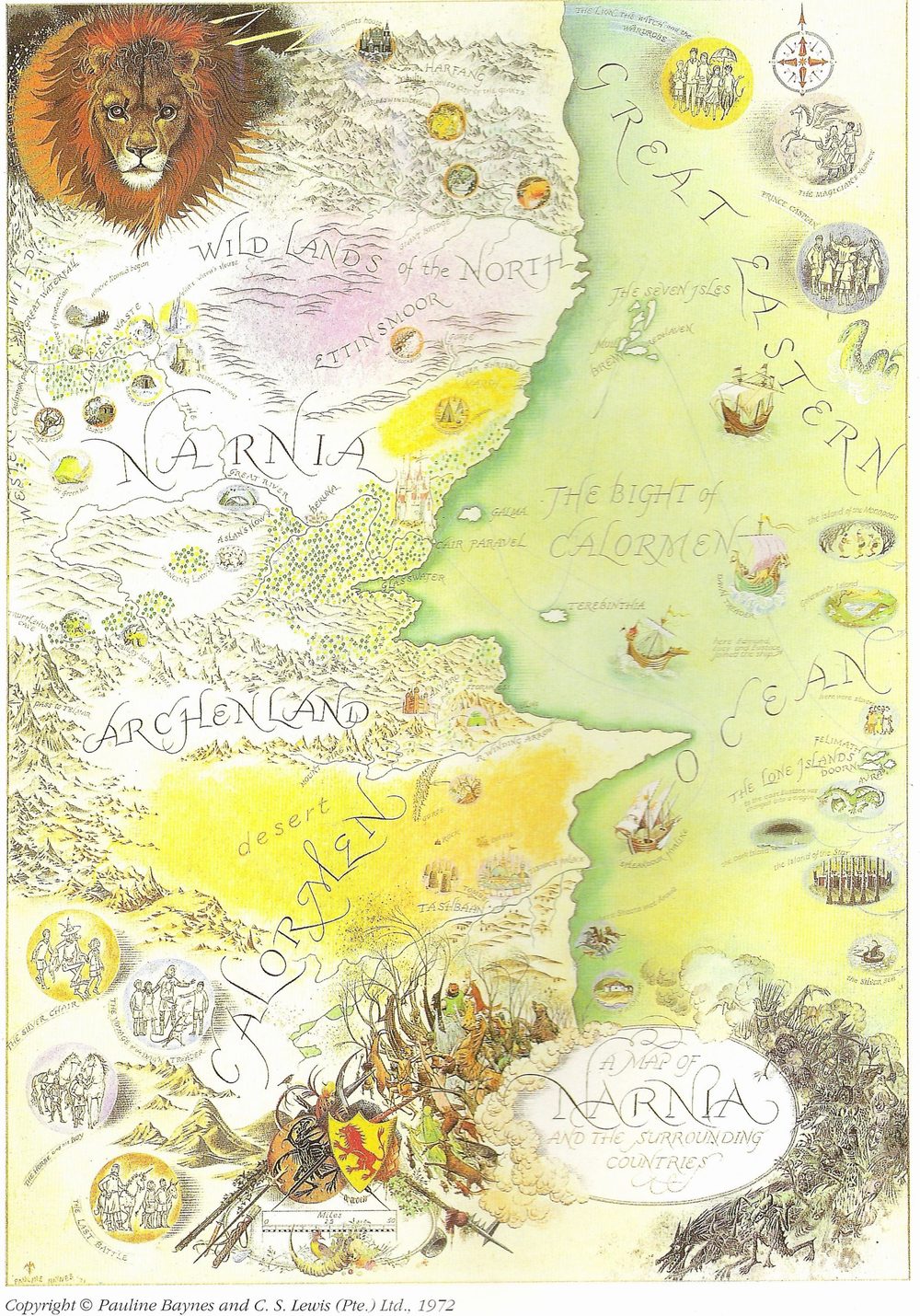
Three maps were used: Pauline Baynes’s colour poster map of 1972 (the template, shown at overview), her black-and-white version of the same map and a CC0 fan redraw of the whole world, both registered onto it for names and coast character only. The printed map does not mark the Fords of Beruna, Aslan’s camp or the tracks between places, so they are placed from the book and marked interpretive; the lamp-post is read from its small unlabelled medallion. Building forms, relief, colours and night lighting are original interpretations, not official art.
- Narnia Fandom: Lamp-post (fan wiki, read through its API)
- Narnia Fandom: Cair Paravel (books)
- Narnia Fandom: Stone Table
Read this map’s source and interpretation notes. The research notes may discuss later-book geography.
Before you explore: spoilers
Places are shown as the first book leaves them, in winter turning to thaw. Names printed on the map from the later Chronicles, such as Archenland, Calormen, Harfang and the islands, are flagged and hidden by default, and place names in this book can still be spoilers. Place cards paraphrase the book with chapter locators and quote nothing.