Wilderland · The Hobbit
The Hobbit map of Wilderland
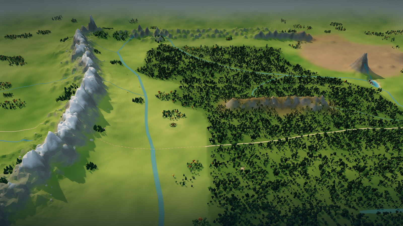
Start with Tolkien’s own Wilderland map from The Hobbit, then zoom into an interactive 3D landscape: Rivendell’s valley, the Misty Mountains, Mirkwood, Beorn’s house, Lake-town and the Lonely Mountain, with Thror’s Map as a layer.
In this atlas
What you can explore
The world is Wilderland in the autumn of 2941 of the Third Age, the year of Bilbo’s journey, and it is spoiler-safe for The Hobbit: nothing from The Lord of the Rings onward is shown as present. It covers the whole of Tolkien’s map, from the Edge of the Wild and the Ford below Rivendell to the Iron Hills, and from the Grey Mountains and the Withered Heath to the Woodmen in Mirkwood’s southern eaves. All 48 places are selectable: Rivendell and the Last Homely House, the pass, Goblin-town, Gollum’s lake and the Goblin-gate under the Misty Mountains, the Eagles’ Eyrie, the Carrock and Beorn’s house, the Forest Gate, the Elf-path and the Elvenking’s halls in Mirkwood, Lake-town on the Long Lake, and the Lonely Mountain with its Front Gate, secret side-door, Ravenhill and ruined Dale, placed from Thror’s Map. Zoom in on Esgaroth for Lake-town: the timber town on its piles out in a calm bay of the Long Lake, the great bridge to the shore, the market-place pool ringed by quays, the Master’s great hall, the mouth of the Forest River where the elves’ barrels come in, and the rotted piles of the older town in the shallows. Hobbiton and Bag End lie west of the map and are not built.
- Open Wilderland
The wider setting
Wilderland map
Tolkien’s map with its rivers, the Long Lake, the ranges, Mirkwood, the roads and the dotted tracks traced, the hero places built at map scale, and Thror’s Map registered over the Lonely Mountain.
A route through the map
Zoom all the way out to see Tolkien’s map unchanged. Move closer to reveal the terrain, forests and buildings. The map is north-up, as Tolkien drew Wilderland (Thror’s Map, drawn with east at the top, is turned to match). Select a place to fly there; night mode lights Lake-town’s lamps on the water, silver light in Rivendell, the Wood-elves’ torches and feast-fires in Mirkwood, Beorn’s firelight and red goblin torches in the pass. Select Lake-town and zoom in to see the town on its piles, lit at night by the lamps of its bridge, quays and great hall. The home control returns to the whole of Wilderland.
Try these starting points:
Questions about this map
Where is the Lonely Mountain on the map of Wilderland?
In the north-east corner of Tolkien’s map, a single peak above the Long Lake, with the Desolation of Smaug round it, the Withered Heath and the Grey Mountains to the north and the Iron Hills off the map to the east. Select it to fly to its Front Gate and the secret side-door on its western face.
What is Thror’s Map and what do its moon-letters say?
Thror’s Map is the book’s other map, the dwarves’ plan of the Lonely Mountain that Gandalf gives Thorin (ch. 1). In Rivendell Elrond finds hidden moon-letters on it that tell the company where to stand and when the last light of Durin’s Day will show the keyhole of the side-door (ch. 3, paraphrased). The atlas registers Thror’s Map onto the Wilderland map and places Dale, the Front Gate, the side-door and Ravenhill from it; the runes themselves are not reproduced.
Where is Lake-town (Esgaroth) in relation to Dale and Erebor?
Lake-town stands on piles in the Long Lake, south of the Lonely Mountain. The River Running leaves the Mountain by the Front Gate, passes the ruins of Dale in the valley between the Mountain’s southern spurs and enters the lake at its northern end, the gateway Thror’s Map names (ch. 10-11).
What does Lake-town look like inside?
The book describes a town of wood built on great piles out in a sheltered bay of the Long Lake, joined to the shore by one long wooden bridge, with a market-place that is a wide pool of still water ringed by quays and the greater houses, and the Master’s hall where he sits feasting when Thorin arrives (ch. 10, paraphrased). The atlas builds those parts at Esgaroth; no plan of the town was published, so the layout and buildings are interpretations.
What is the route from Rivendell through Mirkwood to the Lonely Mountain?
From Rivendell the company climbs the pass over the Misty Mountains and is taken into Goblin-town (ch. 4); Bilbo escapes through the back door (ch. 5) and the eagles carry everyone from the Wargs to their eyrie and then to the Carrock (ch. 6-7). After Beorn’s house they enter Mirkwood at the Forest Gate and follow the Elf-path (ch. 7-8), are imprisoned in the Elvenking’s halls, ride the barrels down the Forest River to Lake-town (ch. 9-10) and go on by the lake and the River Running to the Mountain (ch. 11).
Where are the Misty Mountains, Goblin-town and the Carrock?
The Misty Mountains run down the western part of the map, with Rivendell at their western foot. Goblin-town lies under the pass the company climbs (ch. 4), and its back door, the Goblin-gate, opens on the eastern side. The Carrock is the rock island in the Great River east of the range, with Beorn’s house a little further east (ch. 7).
Are Hobbiton and Bag End on the map?
No. Tolkien’s Wilderland map begins at the Edge of the Wild, with an arrow pointing west to the Western Lands; the Shire, Hobbiton and Bag End lie beyond it and are not built in this atlas.
Are the buildings canon?
No. Positions follow Tolkien’s maps; the shapes of Rivendell, Beorn’s hall, the Elvenking’s gates, Lake-town and the Mountain’s gates are original interpretations drawn from descriptions in the book, not official art.
Geography and artistic interpretation
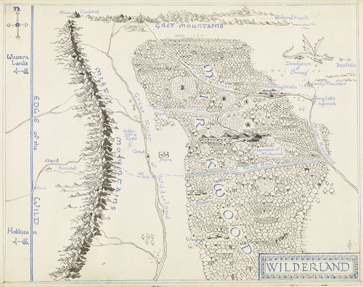
Three maps were used: Tolkien’s Wilderland map printed in The Hobbit (the template, shown at overview), Thror’s Map, the book’s other map, registered onto it for Dale, the Front Gate, the side-door and the Mountain’s spurs, and John Howe’s painted map There and Back Again (HarperCollins, 1995) as a colour and relief reference only. Positions follow Tolkien’s map; places the map does not mark, such as Goblin-town, Gollum’s lake and the trolls’ clearing, are placed from the text and marked as interpretation. Building forms, heights, colours and terrain heights are original interpretations sized to read at map scale. No published plan of Lake-town exists: its bay, bridge, market-place pool, great hall and quays follow the book’s description in chapter 10, and every position and building inside the town is an interpretation.
- The Tolkien Estate: Tolkien’s maps, including Wilderland and Thror’s Map
- Curtis Wright Maps: There and Back Again, the map of The Hobbit by John Howe
Read this map’s source and interpretation notes. The research notes may discuss later-book geography.
Before you explore: spoilers
Places stand as they are during the journey in 2941: Dale is already a ruin, Lake-town stands whole on the Long Lake and the dragon still holds the Mountain. Nothing from The Lord of the Rings onward is shown as present. Place cards cite the chapter where each place appears and can name what happens there; there is no chapter-by-chapter filter.