Temerant · The Name of the Wind
The Name of the Wind map of the Four Corners of Civilization
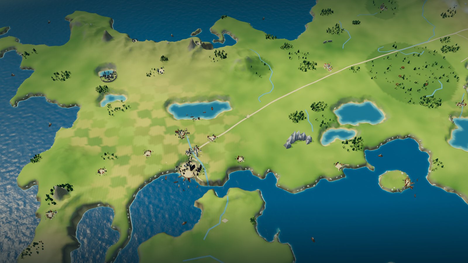
Start with the Four Corners of Civilization map printed in The Name of the Wind, then zoom into an interactive 3D Temerant: the University and Imre by the Omethi, Tarbean on the Reft, Trebon and its church, Newarre and the Waystone Inn, the Eld and the Stormwal wall.
In this atlas
What you can explore
The world is Temerant as the first book shows it: the Four Corners of Civilization, with the Commonwealth and the Cealdish hills in the west, the Aturan Empire and its Great Stone Road across the middle, the dark Eld and the Small Kingdoms in the east and south-east, and the Stormwal Mountains along the eastern edge. It is spoiler-safe for The Name of the Wind: places that only appear in The Wise Man’s Fear are kept out of the map. Positions of the cities, rivers, ranges and forests follow the printed plate; the University and Imre, Tarbean and Trebon are laid out in detail as you zoom in, Newarre is built as a living place, and a handful of villages the maps do not mark sit at interpretive spots.
- Open Temerant
The wider setting
Temerant map
The printed map with its coasts, the Reft and Centhe inlets, nine lakes, rivers, the Great Stone Road, the Stormwal and Ceald ranges and forests traced, the hero cities built at map scale, and the 10th Anniversary Edition’s extra names registered over it.
A route through the map
Zoom all the way out to see the printed map unchanged. Move closer to reveal the terrain, forests and towns. The map is north-up, as the book prints it. Select a place to fly there; night mode lights Imre’s and the University’s lamps, Tarbean’s docks, Trebon’s harvest fires and the Waystone Inn, with fireflies drifting under the Eld. Select the University to cross the Omethi into the campus: by night the sympathy lamps glow white-gold over the Archives, the Mains and the Mews, the Artificery’s forges burn orange under their smokestacks, and fireflies drift through the Woods. Select Tarbean to go down to the Reft: poor Waterside with its quays, the Half-Mast and the tannery’s smoking stack, Seaward Square with its stalls and the Broken Binding, and the pale manors of the Hillside above; by night the quay lanterns and lit windows glow amber, the square’s lamps white-gold, and lamp-moths drift over the Hillside. Select Trebon to ride north into farm country: the stone church with its iron wheel, the inn with its lit sign and the harvest festival ground; by night the pyre, braziers and orange lanterns glow, embers and fireflies drift over the wheat, and Mauthen Farm and the hill Borrorill sit quiet beyond the town. Select Newarre to ride out to the Waystone Inn: the long timber inn with its great chimney, stable and lit sign at the western edge of the town, the Old Stone Bridge over the stream, the church, smithy, bakery and mill; by night the inn’s windows and forecourt glow amber, the forge burns orange, the bridge lamps shine, and fireflies drift over the tamed wood and the fields.
Try these starting points:
Questions about this map
Where is the University in relation to Imre?
The University stands about two miles from Imre, with the river Omethi between them and the Stonebridge carrying the road across. On the map they are two dots close together in the Commonwealth, north of the Reft; select either to fly there. Both are drawn at map scale, and the campus layout comes from the book’s descriptions and a fan plan, so it is interpretive.
Where is Tarbean on the map of the Four Corners?
Tarbean is the great port on the coast of the Commonwealth, on the Reft, close below Imre on the map, though the book makes the trip about two days by coach. The atlas builds it as the book describes it: the crowded Waterside of docks and tenements by the water and the cleaner Hillside above it.
Where is the Waystone Inn, and which town is it in?
The Waystone Inn is in Newarre, the small farming town where the story is framed, on the east side of the map south of the Eld. No official map marks Newarre, so its position is an interpretive guess taken from a fan map; the book describes a town of farms, a bakery, a church, a smithy and an old stone bridge.
Where is Trebon, and how far is it from the Eld?
The book has the Tinker say Trebon lies about sixty miles by road north of Imre and the University (chapter 71). The book gives no distance to the Eld, which is a long way east on the map, and no official map marks Trebon, so its position here is interpretive.
What are the Four Corners of Civilization?
It is the book’s name for the settled, civilized lands of Temerant, the country the printed map draws: the Commonwealth and Ceald in the west, the Aturan Empire across the middle, Vintas, Modeg and the Small Kingdoms to the east, and Yll to the south. The map is the book’s own and is what this atlas traces.
Is there an official map in The Name of the Wind?
Yes. The book prints a black-and-white map called The Four Corners of Civilization, credited by the fan wiki to Nate Taylor, and the 10th Anniversary Edition has a redrawn version with more names. This atlas shows the printed map unchanged at overview and registers the redraw onto it. Trebon, Newarre and a few villages are not on either map.
Are the buildings canon?
No. Positions follow the maps where the maps mark a place; the shapes of the University’s buildings, Imre’s Stonebridge, Tarbean’s docks, Trebon’s church and the Waystone Inn are original interpretations drawn from descriptions in the book, not official art.
Geography and artistic interpretation
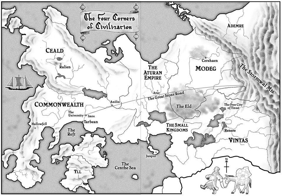
Two published maps were used: the black-and-white Four Corners plate in the book (the template, shown at overview) and the redrawn plate from the 10th Anniversary Edition, registered onto it to read the names the first plate leaves out. A colour redraw with realm borders and a fan map were used only to check outlines and to place the few spots no official map marks, such as Trebon and Newarre, whose positions are interpretive. Buildings, colours and nights are original interpretation drawn from the book’s descriptions, not official art.
- Kingkiller Chronicle Wiki: the Four Corners map and place articles (fan wiki, read through the Internet Archive)
- The Kingkiller Chronicle Wiki: Tarbean
Read this map’s source and interpretation notes. The research notes may discuss later-book geography.
Before you explore: spoilers
Places stand as The Name of the Wind shows them. Places first visited in later books, such as Severen, Haert, the Fae and Tinuë, are not shown. Place cards paraphrase the book with chapter references and quote nothing; read the source notes for what comes from the text and what is interpretation.