Genabackis · Malazan Book of the Fallen
Gardens of the Moon map of Genabackis
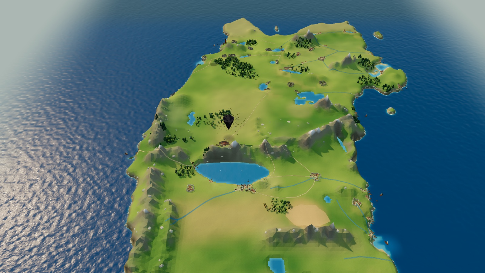
Start with Neil Gower’s map of Genabackis from Steven Erikson’s Gardens of the Moon, then zoom into an interactive 3D landscape: the Free Cities, Pale under siege beneath Moon’s Spawn, the Rhivi Plain, Lake Azur and Darujhistan, the city of blue fire.
In this atlas
What you can explore
The world covers the whole of Gower’s map, from the Hudd Sea and the northern tundra to the Plain of Lamatath and the Cinnamon Wastes in the south. All 112 places are selectable: 53 cities and towns at their printed marks, among them Darujhistan, Pale, Capustan, Genabaris and the old Free Cities, with the seas, lakes, rivers, plains, ranges and forests between them, the Rhivi Trail, the Jaghut barrow in the Gadrobi Hills and the Twins off the southern coast. Moon’s Spawn, which the map does not print, is placed from the text above the plain by Pale. Zoom in on the city for Darujhistan, laid out from Gower’s city plan with all 47 of its places: the outer wall and its five gates, the Second and Third Tier walls, the Gadrobi, Marsh, Lakefront, Daru and Estate districts, Majesty Hill, Despot’s Barbican, K’rul’s Belfry, Hinter’s Tower, the Phoenix Inn, Quip’s Bar, the estates of Baruk, Simtal, Orr and D’Arle, the Mole and its lighthouse, and the shantytowns, hills and roads outside the walls.
- Open Genabackis
The wider setting
Genabackis map
Gower’s map with its coasts, lakes and rivers traced, the cities as walled towns and harbours, Darujhistan’s domes and blue gas-lamps on their tiers, the Malazan camps round Pale and Moon’s Spawn above them.
A route through the map
Zoom all the way out to see Gower’s map unchanged. Move closer to reveal the terrain, forests and towns. The map is north-up. Select a place to fly there; night mode lights Darujhistan in blue, the Malazan campfires round Pale, Rhivi fires on the plain and the Moranth’s coloured lights in the Cloud Forest. Select Darujhistan to open the city itself: by night its gas-light glows blue over every district, with lanterns on the Mole, the lighthouse lamp and warm windows at the inns and estates. The home control returns to the whole of Genabackis.
Try these starting points:
Questions about this map
Where is Darujhistan on the Genabackis map?
On the south-east shore of Lake Azur, in the middle of the continent, with the Gadrobi Hills rising to its east. Gower’s map marks it as the last of the Free Cities. Select it to fly to its domes and blue gas-lamps, or zoom in for the city itself, traced from Gower’s plan.
Where is Moon’s Spawn in Gardens of the Moon?
Gower’s map does not print it. In the opening chapters it hangs over Pale during the siege (Gardens of the Moon, ch. 2), so the atlas shows it above the plain just north-east of the city, with its shadow on the ground below.
Where is Pale in relation to Darujhistan?
Pale lies north of Lake Azur, with the Tahlyn Mountains to its east; Darujhistan is on the lake’s far south-east shore. By the map’s scale bar the two cities are about a hundred leagues apart.
What are the Free Cities of Genabackis?
The independent cities of the continent that the Malazan Empire is campaigning against. Gower’s map marks Darujhistan as the last Free City and others, such as One Eye Cat and Tulips, as previous Free Cities; Pale falls to the Malazan siege in the opening chapters.
Is there an official map of Genabackis in Gardens of the Moon?
Yes. The first edition (Bantam Press, 1999) prints Neil Gower’s map “Genabackis: The Malazan Campaign ca. 1160 Burn’s Sleep” and his plan of Darujhistan. The atlas shows the Genabackis map unchanged at its widest view and lays out Darujhistan from the city plan.
Where is Capustan, and how far is it from Darujhistan?
On the east coast at the mouth of the Catlin, almost due east of Darujhistan and about 185 leagues away by the map’s scale bar.
Are the buildings canon?
No. Positions follow Gower’s map; Darujhistan’s domes, Pale’s keep, Moon’s Spawn and the towns are original interpretations drawn from descriptions in the book, not official art.
Geography and artistic interpretation
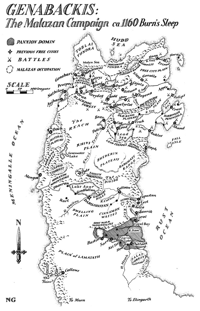
Three maps were used: Neil Gower’s map of Genabackis from the first edition (the template, shown at overview), his city plan of Darujhistan, and the Dutch edition’s re-lettered map of Genabackis, used to check names. Positions follow Gower’s map; building forms, heights, colours, town layouts and terrain heights are original interpretations sized to read at map scale. Moon’s Spawn is not printed on the map and is placed from the text. Darujhistan is registered to Gower’s city plan and checked against the Dutch re-lettered plan; its walls, gates, districts and keyed landmarks sit where the plan draws them, while K’rul’s Belfry stands on the plan’s K’rul’s Hill and the D’Arle estate, which the plan does not mark, is placed among the estates from the text. Houses, lesser streets and building forms in the city are interpretations.
- Malazan Wiki: Neil Gower’s map of Genabackis from Gardens of the Moon
- Malazan Wiki: Neil Gower’s map of Darujhistan


Read this map’s source and interpretation notes. The research notes may discuss later-book geography.
Before you explore: spoilers
Places are shown as Gardens of the Moon opens, with Pale under siege and Moon’s Spawn above it; later outcomes are not shown. Nothing from later Malazan books is mapped beyond the names Gower’s map prints; there is no chapter-by-chapter filter.