The Hampshire downs · Watership Down setting
Watership Down map: the rabbits’ Hampshire in 3D
Explore the Hampshire downs from Richard Adams’s Watership Down: start with the map printed in the book, then zoom into an interactive 3D chalk country of turf downs, hedged fields, copses and clear rivers, with Sandleford, Cowslip’s Warren, Nuthanger Farm, Honeycomb, Efrafa and the Down itself.
In this atlas
What you can explore
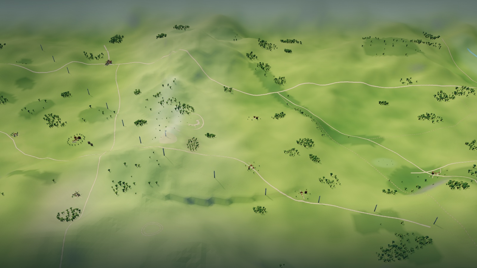
The map opens like the plate printed in the book, with north at the left as the book prints it: Sandleford and the River Enborne at the west end, the heather and Cowslip’s Warren, Nuthanger Farm below Ecchinswell, the long line of Cannon Heath Down, Watership Down and Hare Warren Down with the beech hanger on its slope, the Roman road and Caesar’s Belt, and the clear River Test beside Overton, Laverstoke and Efrafa at the east end. Zoom closer and the printed roads, rivers, woods and downs rise into terrain, with the five warrens drawn as burrow mouths in banks and woods, brick farms, the three market towns of Kingsclere, Overton and Whitchurch, the railway and its arch, the line of pylons and the bridges over the Test. The map shows the setting and its landmarks, not the plot; zoom in on Sandleford Warren at the west end, Cowslip’s Warren on the heath, Honeycomb on the Down, Efrafa by the railway and Nuthanger Farm below Ecchinswell to see each in detail.
- Open The Hampshire downs
The wider setting
The Hampshire downs map
The printed map with its roads, the Enborne and the Test, woods, downs, railway and pylon line traced, fifty places placed at their printed positions, five warrens as burrow clusters, Nuthanger Farm in its ring of elms, three towns, villages, farms and bridges, and the beech hanger on the Down.
A route through the map
Zoom all the way out to see the printed map unchanged. Move closer to reveal the terrain, the downs and the warrens. The map is shown as the book prints it, with north at the left. Select a place to fly there; night mode lights the burrow mouths, fireflies and glow-worms in the hanger and the copses, the cowslips on Cowslip’s lawn, the cold tips of the pylons, moon-silver sparkle on the Test, the glow of the weed pool and the farm windows, and a few headlights on the main road. By day a flock of gulls wheels over the river.
Try these starting points:
- Watership Down
- The Beech Hanger
- Sandleford Warren
- The Notice Board
- Sandleford Warren Burrows
- Cowslip’s Warren
- Cowslip’s Warren Burrows
- The Shining Wires
- The warren’s feeding ground
- Honeycomb
- The Honeycomb Burrows
- The beech hanger
- The open down
- Bank and ditch of the down
- Efrafa
- Efrafa Warren
- The Crixa
- Railway bank at Efrafa
- Warren marks and runs
- Nuthanger Farm
- Nuthanger Farmhouse
- The Rabbit Hutches
- Cottington’s Hill
- Ladle Hill
- Great Litchfield Down
- Frith Copse
- Caesar’s Belt
- The Heather
- Enborne Crossing
- River Enborne
- River Test
- The Punt
- The Weed Pool
- The Railway Arch
- Kingsclere
- Overton
- Whitchurch
Questions about this map
Where is Watership Down in real life?
Watership Down is a real chalk down in north Hampshire, near Kingsclere and Ecchinswell, a few miles south of Newbury. Richard Adams set the story on that real ground between Newbury and Overton. The printed map marks the down with a spot height of 779 feet and its beech hanger at D9, and the atlas builds it as a turf crest with the hanger on its slope.
Is Watership Down a real place?
The hill, the towns and villages and the rivers Enborne and Test on the map are real Hampshire and Berkshire places. The warrens in the book, Cowslip’s Warren, Efrafa and Honeycomb, are the author’s. The atlas separates the two: map positions come from the printed plate, and the burrows and snares are interpretation.
Where is Efrafa on the map?
The Map References put Efrafa and the Crixa at D15, between New Barn and Plank Bridge, near the River Test and the railway at the east end of the plate. The atlas draws it as groups of burrows in the bank with sentry mounds, which is an interpretation.
Where is Sandleford Warren?
At the lower left of the printed plate, grid A1, where the Map References say the story opens, beside Sandleford Park and the River Enborne. Open it from its dot to enter the warren: a low turf bank under the edge of Sandleford wood with a cluster of dark burrow mouths and worn runs, the notice board on its two posts in the field edge, Sandleford Park and its lane beyond, and the Enborne running to the east. The map prints no plan of the warren, so the bank and the burrows are an interpretation.
What is there to see in Sandleford Warren, and where is the notice board?
Zoom in on Sandleford Warren’s dot at the west end of the map. The burrow mouths open along a low turf bank under the edge of the wood, with spoil fans and worn runs in front and one larger mouth for the Chief Rabbit’s Owsla. The feeding ground and its broken hedge-bank lie to the south, and the developers’ notice board that frightens Fiver stands on two posts at the field edge (chapter 1). Night brings amber glows at the burrow mouths and fireflies over the field. The book gives no plan of the warren, so the bank, the runs and the field are an editorial reading, not a printed one.
Where is Nuthanger Farm?
At D7 on the plate, just below the village of Ecchinswell and beside the Barns marked on the map. Zoom in on its dot to see a red-brown brick farmhouse with a pale stone front toward the down, a staddle barn and a byre facing each other across the beaten-earth yard, five rabbit hutches with wire fronts against the house’s end wall, and a ring of elms on the knoll (Part III). Night brings lit windows, a bright porch door, yard, hutch and kennel lamps, fireflies, a silver pond and rooks over the elms. The book gives no plan of the farm, so the buildings and yard are an editorial reading, not a printed one.
Where is Cowslip’s Warren?
At C4 on the plate, beside a stippled field just below Frith Copse. Open it from its dot to enter the warren: a bank of tidy burrow mouths under the edge of Frith Copse, a lawn of cowslips in front as the feeding ground, and the snare lines strung on its far side with a hawthorn hedge beyond. The map prints no plan of the warren, so the bank, the cowslips and the line of the snares are an interpretation.
What are the Shining Wires in Cowslip’s Warren, and what is there to see?
The Shining Wires are the wire snares strung round the warren’s feeding ground, set on pegs along the rabbits’ runs, which the rabbits there call by a gentler name (chapters 12 to 14). Open Cowslip’s Warren from its dot at C4 and you see the burrow bank under Frith Copse, drifts of cowslips on the feeding ground and three staggered rows of stakes with silver loops running out to the hedge. Night brings amber glows at the burrow mouths, softly luminous cowslips, moon-silver snare loops, fireflies and wood pigeons over the copse. The book gives no plan of the warren, so the layout is an editorial reading, not a printed one.
Where is Honeycomb, and what is there to see in the beech hanger?
Honeycomb is the warren the travellers dig under the beech hanger on the slope of Watership Down, whose north-east corner the Map References give at D9 (Part II). Zoom in on its dot on the Down to see seven round burrow mouths set in honeycomb-pattern chalk cells with earth fans and worn runs among the gripping roots of the grey beeches, copper leaf litter and bluebell glades under the hanger, the barrows and summit turf of the open down above, and the bank and ditch where the Down meets the wood and the fields. Night brings amber glows in honey-gold cells at the burrow mouths, moon-silver barrows, fireflies climbing the hanger and lapwings over the down. The book gives no plan of the warren, so the layout is an editorial reading, not a printed one.
Where is the Crixa, and what is there to see at Efrafa?
The Crixa is the open place inside Efrafa where two bridle paths cross and Woundwort meets his officers (Part III); the Map References give Efrafa and the Crixa together at D15, beside the River Test and the railway at the east end of the plate. Zoom in on its dot to see groups of burrow mouths with bare rings and worn runs on the swell of the warren, the Crixa as a pale clearing with an X of paths, a flat stone and a ring of lamps, the brick arch through the railway bank, and the grazed patches of the Marks with their sentry mounds and lookout posts. Night brings a calm bright ring on the Crixa, lamp-lit crests along the bank, lantern-white watchers, glow-worms and fireflies. The book gives no plan of the warren, so the layout is an editorial reading, not a printed one.
What route did Hazel and the rabbits take from Sandleford to Watership Down?
The Map References trace Part I from Sandleford at A1 over the River Enborne at B2 and across the heather at C3 to Cowslip’s Warren at C4, and Part II ends on the down with the beech hanger at D9. The map does not draw the route itself, so the atlas marks only those places and does not trace a path.
Geography and artistic interpretation
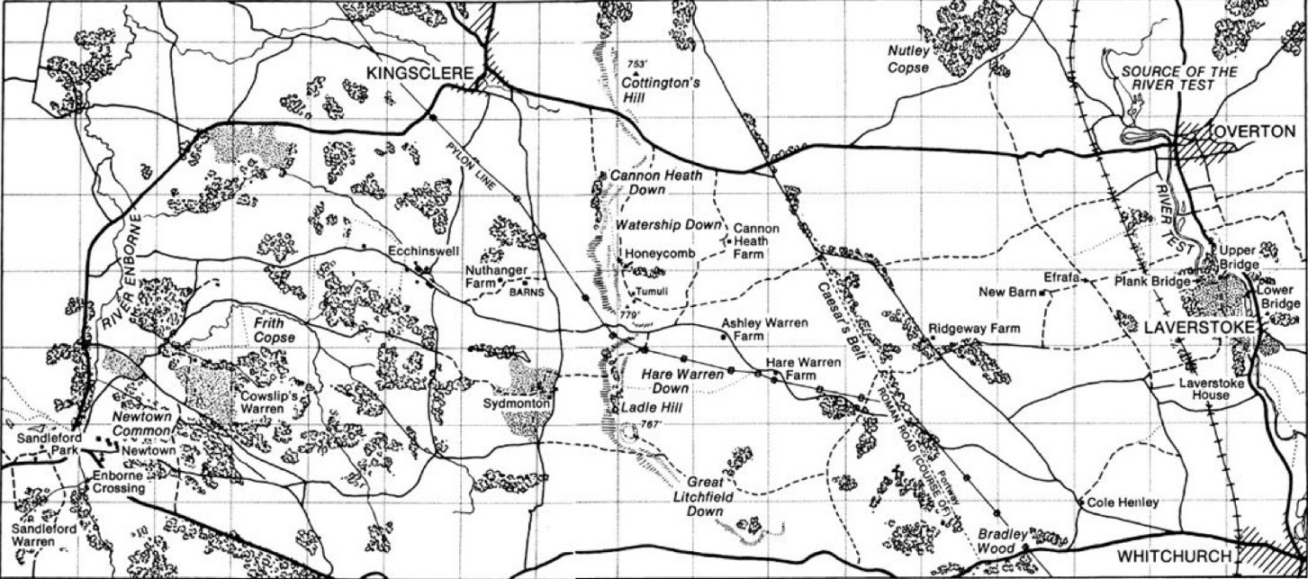
Three maps were used: the plate printed in the book, as filed on the Watership Down Wiki (the template, shown at overview and cropped to its printed frame), and two reference maps of the real ground registered onto it, OpenStreetMap and OpenTopoMap, which supply the detail behind the plate. Where they disagree the printed plate decides. Warrens, burrow mouths, snares, farm buildings, terrain heights, colours and night lighting are original interpretations drawn from the book’s descriptions, not official art.
- Watership Down Wiki: Watership Down (Hampshire)
- Watership Down Wiki: the map printed in the book (File:1972NovelMap.jpg)

Read this map’s source and interpretation notes. The research notes may discuss later-book geography.
Before you explore: spoilers
Places stand as the book’s own map and Map References list them. The atlas shows no events as having happened, and nothing from Tales from Watership Down, the film or the television series is used. Place cards paraphrase the book with part and chapter locators and quote nothing.